Gold Canyon Location and Geology
The site and situation of Gold Canyon, AZ
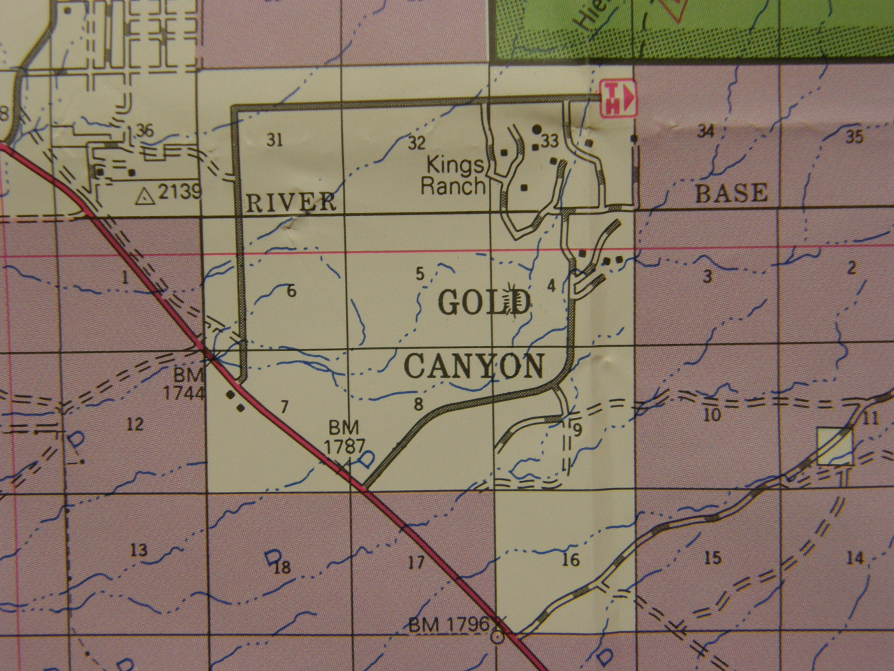
Each square on this map (called a "section") measures one mile by one mile, so the community of Gold Canyon is in a square 3 miles on a side, creating an area of 9 square miles, plus one additional square (block 16), for a total of ten square miles. The red diagonal line is US Route 60, the major divided highway through the region.
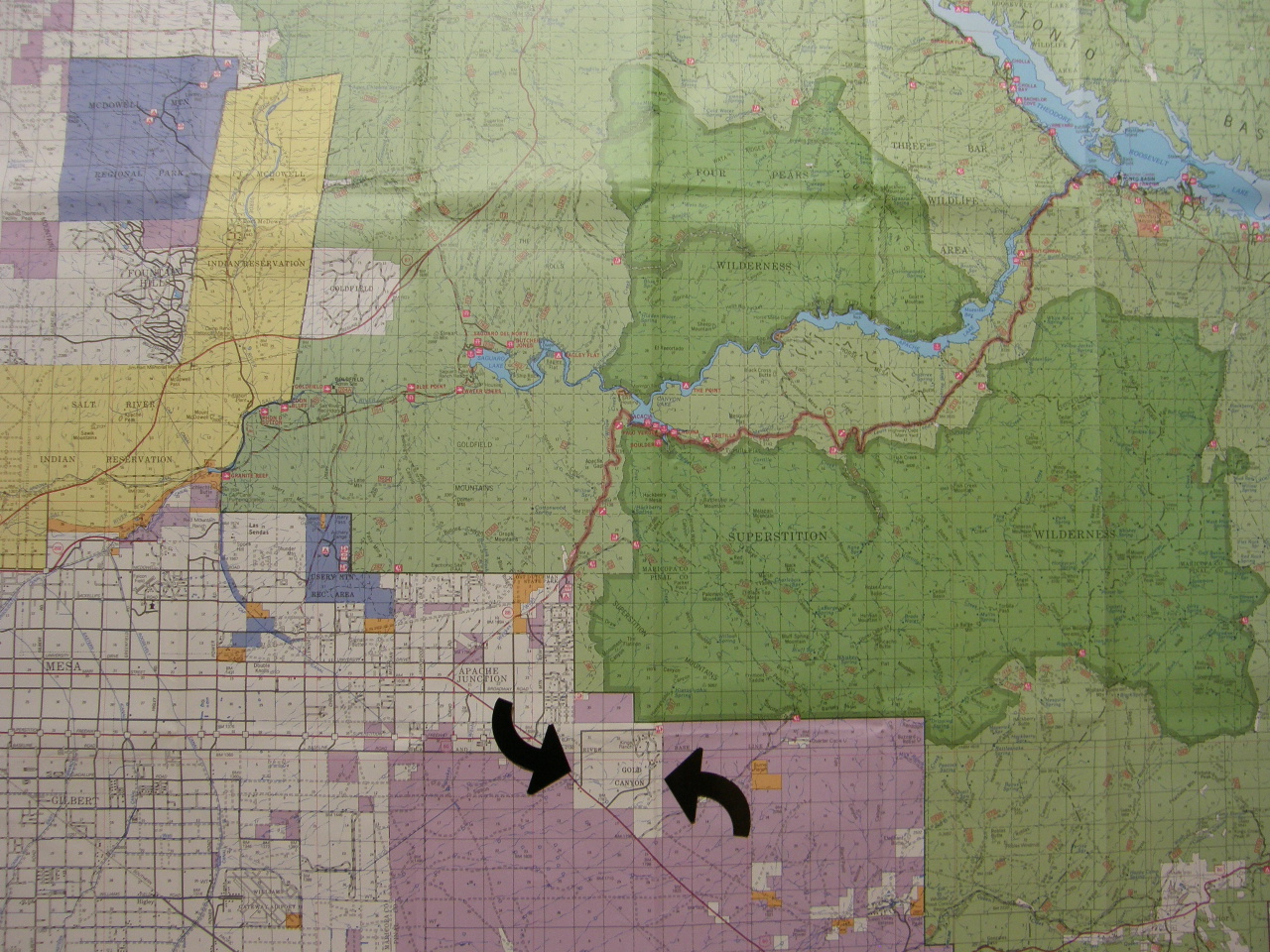
The arrows show Gold Canyon as the white area, with US60 slicing through it but turning to the direct west near the center of the map. If you continue US60 westward about 35 miles you get to central Phoenix. The dark green areas north of Gold Canyon are the Superstition Mountains and the purple areas on the map are AZ state undeveloped lands which could someday be sold and developed.
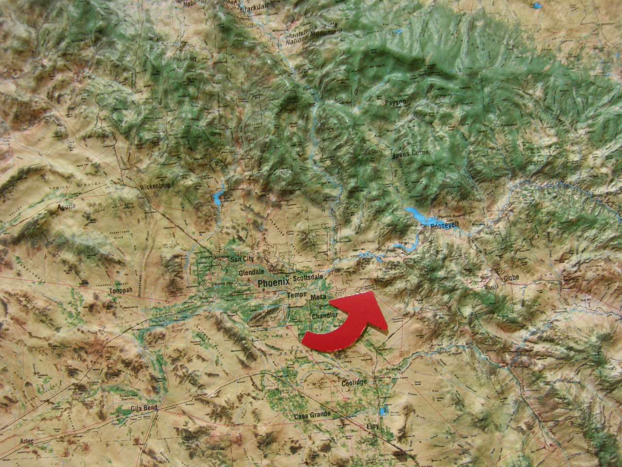
This topographic map shows the location of Gold Canyon with the bold arrow. To the east of Gold Canyon, the topography is an eroded high plateau, and to the west it is fault block mountains that have been partially or completely covered with alluvium (weathered rock material). So Gold Canyon is in a transitional area between these two geologic regions.
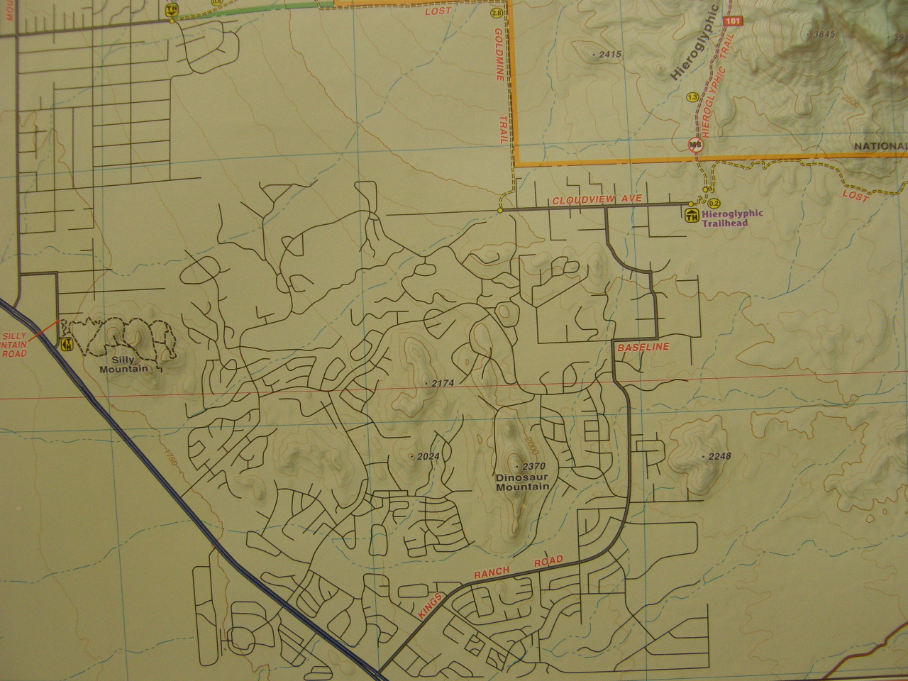
This is the road pattern within the nine square mile block of Gold Canyon. My home is just west of the central peak marked "2174." Along the western edge is "Silly Mountain" and southeast of the central peak is "Dinosaur Mountain." Both will be considered separately on this web site.
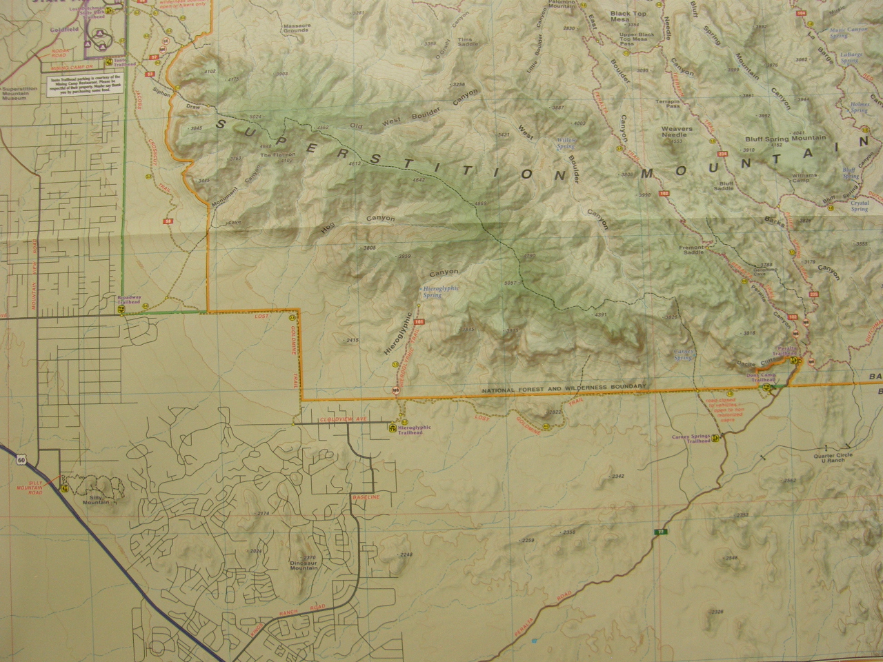
Here is an expanded view of the road pattern of Gold Canyon and the surrounding area. The abrupt edge of the Superstition Mountains lies along the northern boundary of the map. Just west of Gold Canyon lies the city of Apache Junction and west of that is the edge of the next city, Mesa. The next city to the east is Superior which is about 15 miles away.
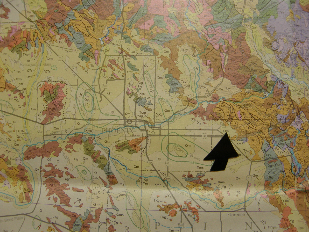
The black arrow points to the location of Gold Canyon. (Actually Gold Canyon is just a tiny bit south of the arrow tip -- sorry!) The main east-west highway that runs through an edge of Gold Canyon, US route 60, continues about 35 miles to downtown Phoenix. Going eastward from downtown Phoenix, route 60 bends toward the southeast very near Gold Canyon to avoid the rugged topography of the bedrock mountains that are relatively young volcanics as well as part of the faulted and dissected plateau that lies to the east. West of Gold Canyon, the bedrock also has been faulted, but in this region the area was stretched and, in response to the stretching, the faulted blocks have tilted and decreased in elevation as part of the Basin and Range province. The various yellow colors on the map indicate alluvium (weathered rock debris) from the erosion of the mountains which has been transported primarily by a few permanent rivers and many ephemeral streams to accumulate between the tilted block edges to make a relatively flat depositional surface with a few eroded bedrock mountain blocks conspicuously exposed. This alluvium is very deep in some locations. The green contour lines nearest to Gold Canyon are labeled 4,800 and 9,600 feet, indicating that the depth to bedrock in the Higley Basin, the nearest basin to Gold Canyon, is more than 10,000 feet. Many portions of Gold Canyon are built on a very thin edge of this alluvial veneer, but my home, as well as some others, is constructed on the slope of a bedrock hill that is composed of the volcanic rock dacite.
The deep alluvial fill is the repository of most of the groundwater resources upon which much of the Phoenix metropolitan area depends. During years with higher-than-average rainfall the extra water is pumped ito these alluvial deposits, only to later be pumped back to the surface during drier-than-average times. This "water banking" in these extensive alluvial aquifers solves the problem of evaporative water loss from surface reservoirs. When groundwater is withdrawn from these aquifers, the pore spaces in the deposit contract and the surface often sinks in elevation. Sometimes ground fissures form on the surface which creates engineering problems for roads and structures there.
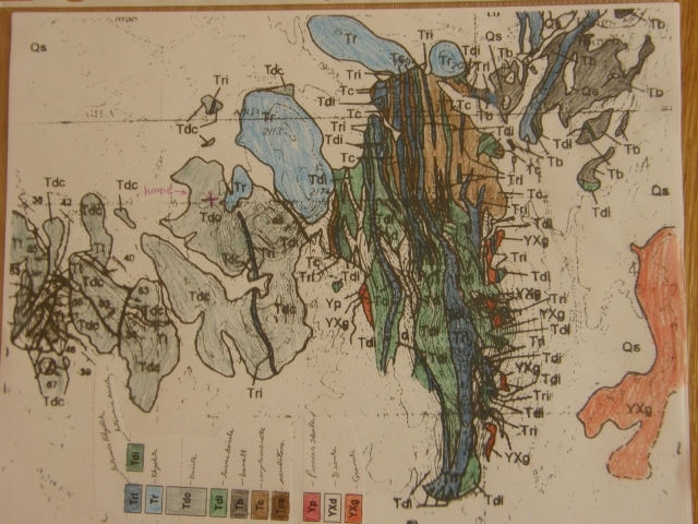
On the above hand-colored geologic map* of Gold Canyon, the exposed bedrock hills are colored, but the alluvial material between the bedrock exposures is left uncolored. The location of my home is indicated by the red "+" which is located in the area colored gray and marked with the symbol "Tdc," which is the volcanic rock dacite.
The above hand-colored map is taken from the Arizona Geological Survey Open File Report 95-9 by Skotnicki and Ferguson. The map was made in 1995, so most of the roads in the present Gold Canyon community were not yet built at that time.
The cross section below shows the alluvial valley fill as shades of gray and leaves the bedrock beneath the alluvium undifferentiated and uncolored. The cross section runs from the SSW on the left edge to the NNE on the right edge where it intersects the Superstition Mountains. The many wells drilled into the shallow valley fill near the right edge are probably located in the Kings Ranch Road area of Gold Canyon. The shallow bedrock surface beneath the alluvial fill is called a pediment and formed by erosion of the bedrock with a progressively rising baselevel.
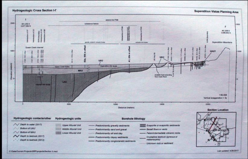
The figure above is cross section I-I' in Subsurface Hydrogeologic Investigation of the Superstition Vistas Planning Area, Maracopa and Pinal Counties, Arizona, by Brian F. Gootee, Joe Cook, Jeri J. Young, and Phil A. Pearthree, published by the Arizona Geological Survey and dated July, 2017.
For additional information about the commmuity of Gold Canyon, see the following website:
https://goldcanyon.net
For the latest geologic map and associated report on Gold Canyon and the nearby Superstition Mountain, see the following:
http://repository.azgs.az.gov/uri_gin/azgs/dlio/246
Rhyolite and dacite are common igneous rocks in this area. Here are links that give more detail about these similar rocks:
https://flexiblelearning.auckland.ac.nz/rocks_minerals/rocks/rhyolite.html
and
https://flexiblelearning.auckland.ac.nz/rocks_minerals/rocks/dacite.html